NETHERLANDS · ENSCHEDE
International Institute for Geo - Information Science and Earth Observation
public · Founded 1950 · Languages: en
In short
The International Institute for Geo-Information Science and Earth Observation (ITC) at the University of Twente offers specialized Master's programs and research in geo-information science and earth observation. They focus on global challenges and have specific tuition fees and living cost estimates for international students.
Key facts
- Type
- Public
- Founded
- 1950
- Students
- 700
- International students
- 550
- Acceptance rate
- 50%
- Tuition (intl)
- €16–21k/yr
- Languages
- EN
- Location
- Enschede, Netherlands
The International Institute for Geo-Information Science and Earth Observation (ITC) is a leading faculty at the University of Twente in the Netherlands. It specializes in geo-information science and earth observation, offering world-renowned education, scientific research, and technology development in these fields. ITC is dedicated to addressing global challenges aligned with the United Nations Sustainable Development Goals, focusing on areas like food security, sustainable agriculture, energy transition, geo-health, climate change adaptation, urban development, disaster risk reduction, and land administration. ITC provides a range of Master's degree programs and online courses through its 'Geoversity' platform, designed to enhance skills and keep students updated with technological advancements. Research at ITC is structured across six scientific departments: Earth Observation Science, Applied Earth Sciences, Geo-Information Processing, Natural Resources, Urban and Regional Planning and Geo-information Management, and Water Resources. These departments serve as centers of excellence, fostering interdisciplinary collaboration to tackle complex global issues. Beyond academic contributions, ITC is actively involved in practical projects and collaborations worldwide, aiming to create a significant impact. The institute emphasizes cross-disciplinary facilities and strong partnerships to ensure its educational, research, and project services contribute to developing highly skilled geospatial professionals and driving impactful solutions.
Why study here
- Contribute to solving global challenges like climate change, food security, and disaster risk reduction.
- Access to world-leading expertise and research in geo-information science and earth observation.
- Benefit from interdisciplinary research and collaboration within specialized scientific departments and centers of expertise.
- Engage with practical, impactful projects that directly address real-world issues.
- Study at a faculty within the University of Twente, providing a broader university experience and resources.
Student life
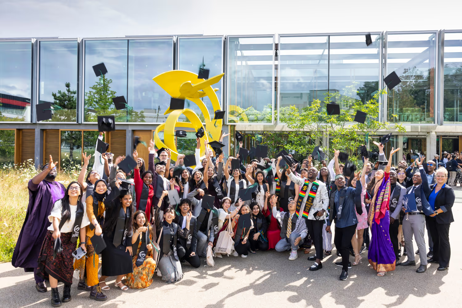
As a specialised graduate faculty within the University of Twente, ITC offers a small, highly international community where students from dozens of countries study and research together in Enschede. Students benefit from the wider University of Twente green campus, with sports facilities, student associations, accommodation and cultural activities, while ITC's own student hotel and close-knit cohorts foster a supportive, collaborative atmosphere geared towards professional geospatial training.
Fees
InternationalAs a faculty of the University of Twente, ITC charges institutional (non-EU/EEA) tuition for its Master's programmes, typically around EUR 16,000 to EUR 21,000 per year depending on the programme.
HomeEU/EEA students pay the Dutch statutory tuition fee, which is substantially lower than the institutional rate (around EUR 2,500 per year for a first Master's).
LivingLiving costs are likely between €500 and €750 per month (for visiting researchers, excluding accommodation). Degree students in Enschede should budget roughly EUR 900-1,200 per month including accommodation.
Visiting researchers and post-doctoral fellows do not pay tuition fees for research, but must pay appropriate tuition fees to follow complete modules.
Admissions
MSc degreeRequired (from ITC or other university/institute)
Research proposalOutline (1-2 pages) required as part of registration
CVRequired
Passport scanRequired
BSc diploma + transcriptsRequired
MSc diploma + transcriptsRequired
IELTSCertificate required if studies were not in English (typically 6.5 overall for Master's entry)
TOEFL90 or above (iBT) for Master's entry
Rankings
University of Twente (ITC)World's top institutes for academic education
QS World University Rankings by Subjecttop 200 (Geography, via University of Twente)
University scholarships
ITC Partial Scholarships—
Orange Knowledge Programme / NL ScholarshipDutch government-funded scholarships supporting students from eligible developing countries for ITC Master's study.
Accreditation
ITC is a faculty of the University of Twente.
For international students
NetherlandsStudent visa & funds
Non-EU students cannot apply for their own residence permit; only an IND-recognised institution (a registered sponsor) submits the application on their behalf. The permit is issued for up to five years and stays valid for three months after the programme ends. For university and HBO students the IND requires proof of at least €1,130.77 per month (the 2026 study norm) for living costs, held by the student or guaranteed by the institution. Students must also keep satisfactory progress — at least 50% of annual credits — to retain the permit.
Working while you study
Non-EU students may work a maximum of 16 hours per week during the academic year, or alternatively full-time during June, July and August. In either case the employer must first obtain a work permit (TWV) from the UWV before the student starts; the student cannot apply for it themselves. Internships that are a formal, graded part of the degree are exempt from the TWV requirement when a tri-party agreement is in place, as is volunteering with a Volunteer Declaration.
After you graduate
After a bachelor’s, master’s or PhD at a Dutch institution, non-EU graduates may apply for the orientation year permit (zoekjaar), valid for one year and not extendable. During this year the holder may work freely — no employer TWV is needed — and may also freelance or start a business. The application must be made within three years of graduating. Graduates of a foreign university ranked in the global top 200 can also qualify with English proficiency at IELTS 6.0 or equivalent.
English tests
- IELTS6.0–6.5 for bachelor’s; 6.5–7.0 for most master’s; specialist master’s up to 7.0–7.5
- TOEFL iBT80–90 for bachelor’s; 90–100 for master’s; some research universities require 100
Main intakes
SeptemberFebruary
Typical living cost
€1,200/month
Approximate all-in student budget; major cities run higher.
Programs
a selectionInternational Institute for Geo - Information Science and Earth Observation · Netherlands
A New Way to Map Small-Scale Irrigation Areas
This program focuses on identifying and mapping small-scale irrigation areas, a critical task for effective water resource management and food security. It introduces a novel method that combines high-resolution multispectral time-series satellite imagery with digital elevation model (DEM) analysis and expert local knowledge. This approach is particularly useful in complex topographic and semi-arid environments, offering a more accurate way to delineate irrigated land compared to previous methods. The method was developed and tested in the Zamra catchment in Ethiopia, a region prioritizing agricultural irrigation expansion to improve livelihoods and food security. The course will delve into the steps involved in this new approach, including setting expert-defined thresholds for various geographic and spectral data, applying a random forest classifier for mapping, and characterizing different irrigation scheme types. By learning this technique, participants can contribute to better water management strategies and support food security initiatives. The course also touches upon the importance of utilizing publicly available satellite data and cloud services for hydrological analysis.
Certificate
Level
Free
Tuition
8 mo
Duration
International Institute for Geo - Information Science and Earth Observation · Netherlands
A Survey of Active Learning for Quantifying Vegetation Traits from Terrestrial Earth Observation Data
This study explores the use of Active Learning (AL) techniques to improve the analysis of Earth Observation (EO) data for monitoring vegetation. As satellite data streams increase, efficient methods are needed to translate this data into useful information about vegetation properties. The research focuses on hybrid retrieval approaches, which combine physical models (Radiative Transfer Models) with machine learning algorithms. AL can help by intelligently selecting the most informative data samples for training these algorithms. The paper summarizes AL theory, reviews its application in EO, and presents a case study demonstrating how AL can enhance the accuracy and speed of estimating vegetation traits like leaf pigment and water content. The findings suggest that AL-based sampling is a valuable method for optimizing regression accuracy, reducing processing time, and facilitating data analysis for vegetation monitoring.
Master's
Level
—
Tuition
—
Duration
International Institute for Geo - Information Science and Earth Observation · Netherlands
AgroEcological Transitions: Changes and Breakthroughs in the Making
This publication explores the dynamic field of agroecological transitions, focusing on system innovations, knowledge regimes, and design practices essential for sustainable agriculture. It stems from the second 'System Innovation towards Sustainable Agriculture' (SISA) workshop, held in Paris in 2014, which brought together researchers and practitioners to share insights and experiences. The collection of papers examines various approaches to analyzing and governing sustainability transitions in agriculture. It aims to provide a basis for effective strategies that can stimulate the development of more sustainable agro-food systems. The work considers diverse agricultural sub-sectors and emerging innovations, investigating how different actors can influence these transitions.
Master's
Level
—
Tuition
24 mo
Duration
International Institute for Geo - Information Science and Earth Observation · Netherlands
Analysis of Reservoir and Steam Flow Data in Olkaria Domes Geothermal Field, Kenya
This research focuses on the performance of the Olkaria Domes Geothermal Field in Kenya, examining reservoir conditions and steam production between 2019 and 2023. The study specifically analyzes key wells that supply power to Olkaria IV, Olkaria V, and nearby wellhead power plants. Data indicates stable wellhead pressures and discharge enthalpies, typical for a high-temperature geothermal system, with reinjection rates helping to maintain reservoir pressure. However, the research also identified signs of cooling and dilution in certain wells, evidenced by decreased enthalpy and silica concentrations. This suggests that the colder fluids being reinjected may be encroaching into the reservoir. The study utilized discharge test data and pressure logging to analyze mass flow rates, pressure trends, and thermodynamic conditions. The findings highlight the critical need for ongoing monitoring of the geothermal reservoir and optimizing reinjection strategies. These measures are essential to prevent long-term pressure depletion and thermal degradation, ensuring the sustained supply of steam and the long-term viability of geothermal energy production at the Olkaria Domes field.
Master's
Level
—
Tuition
—
Duration
International Institute for Geo - Information Science and Earth Observation · Netherlands
Climate Change Adaptation Policy Landscape, Institutional Arrangements, and Implementation in South Africa
This program focuses on the policy, institutional, and implementation aspects of climate change adaptation within South Africa. It examines the landscape of policies and governance structures at international, national, provincial, and local levels, aiming to build climate resilience and integrate adaptation strategies into development planning. The curriculum delves into understanding climate change impacts, risks, and vulnerabilities, and explores the mechanisms for mobilizing resources and fostering coordination across various sectors and government spheres. It also addresses the role of research, capacity building, and international cooperation in achieving South Africa's climate adaptation goals and meeting its global commitments. The program explores the evolution of climate change policy in South Africa, from early responses and international engagements to the development of comprehensive strategies like the National Climate Change Adaptation Strategy (NCCAS). It highlights the importance of a coordinated, multi-governance response, involving local government, sectoral policies, and national frameworks. The program also considers the legislative underpinnings, such as the Climate Change Bill, and their role in enabling a just transition to a low-carbon, climate-resilient economy and society. Ultimately, this program seeks to equip participants with the knowledge and understanding to contribute effectively to the implementation of climate change adaptation measures, enhancing resilience, and ensuring sustainable development in the face of a changing climate.
Diploma
Level
—
Tuition
—
Duration
International Institute for Geo - Information Science and Earth Observation · Netherlands
CRISP: Satellite Data for Global Rice Climate Resilience and Food Security
CRISP (Consistent Rice Information for Sustainable Policy) is a digital mapping platform designed to provide global, timely, and detailed information on rice production using Earth Observation data. It addresses the need for consistent and spatially granular production data, which is often delayed and may not fully account for climate events. Developed by a consortium including sarmap and IRRI, CRISP builds on the success of the RIICE service, which has been piloted in various rice-growing regions across Asia, Africa, and South America for over 12 years. The platform leverages multi-temporal Sentinel-1 and -2 satellite data to generate seasonal rice maps. This data supports governments, international organizations, and the private sector in making informed decisions regarding rice production. CRISP offers a dynamic, user-driven analysis approach, moving beyond static reporting to provide actionable intelligence.
Certificate
Level
—
Tuition
—
Duration
Scholarships
for Netherlands full funding
Dutch Research Council (NWO)
NWO Rubicon Programme
For researchers who have recently completed (or are about to complete) a PhD, who want to gain research experience at a foreign institution (or at a Dutch institution if coming from abroad). It is a postdoctoral programme; applicants must have obtained their doctorate within the last ~12 months and apply through NWO with a host.
full
Funding
€180k
Max
Mar 31, 2027
Deadline
full fundingNuffic (Dutch Ministry of Foreign Affairs)
Orange Knowledge Programme (OKP) Scholarships
Open to mid-career professionals who are nationals of, and currently living and working in, one of the listed OKP partner countries. Applicants must have proficiency in English or French, be in work that aligns with one of the priority areas designated for their country, be able to show they will use and transfer their new knowledge within their employing organization, and agree to comply with the obligations and conditions of the OKP. A limited number of awards is granted to motivated female and male professionals.
full
Funding
€40k
Max
Mar 31, 2027
Deadline
 full funding
University of Groningen
Welcoming International Talent (WIT) PhD Fellowship
Open to Early-Stage Researchers of any nationality who, at the call deadline, have no more than four years of full-time-equivalent research experience and have not yet been awarded a doctoral degree. Applicants must hold a qualification that grants access to doctoral studies, meet the MSCA mobility rule (not having lived or worked in the host country for more than 12 months in the previous three years), and have at least certified B2-level English.
full
Funding
€32k
Max
Mar 18, 2027
Deadline
 full funding
Maastricht University
UM Brightlands Talent Scholarship
Open to non-EU/EEA and Swiss nationals under 35 who have conditional admission to a participating master's programme affiliated with a Brightlands campus, have not previously enrolled in Dutch higher education, and demonstrate strong academic performance.
full
Funding
€31k
Max
Feb 1, 2027
Deadline
full fundingMaastricht University
Maastricht University NL-High Potential Scholarship
Open to talented students from outside the EU/EEA, Switzerland and Suriname who have applied for admission to a participating full-time Master's programme at Maastricht University, meet the programme's admission requirements, have not previously studied for a degree in the Netherlands, and are no older than 35 on the cycle's start date.
full
Funding
€30k
Max
Feb 1, 2027
Deadline
 full funding
Delft University of Technology (TU Delft)
Justus & Louise van Effen Excellence Scholarship
For exceptional non-EU/EEA students applying for an MSc programme at Delft University of Technology (TU Delft) with an excellent academic record. The scholarship is merit-based and competitive; you apply for it after applying for admission to an eligible TU Delft master's, by the deadline (commonly 1 December).
full
Funding
€30k
Max
Dec 1, 2026
Deadline
Frequently asked questions
What subjects does the International Institute for Geo-Information Science and Earth Observation (ITC) specialize in?
+
ITC specializes in geo-information science and earth observation, offering world-renowned education and research in these fields. Their work is dedicated to addressing global challenges aligned with the United Nations Sustainable Development Goals.
What degree programs are available at ITC?
+
ITC provides a range of Master's degree programs and online courses through its 'Geoversity' platform. Their research is structured across six scientific departments focusing on specialized areas within geo-information science and earth observation.
What are the tuition fees for international students at ITC?
+
As a faculty of the University of Twente, ITC charges institutional tuition fees for non-EU/EEA students, typically ranging from EUR 16,000 to EUR 21,000 per year depending on the Master's program.
What are the estimated living costs for students in Enschede?
+
Degree students in Enschede should budget roughly EUR 900-1,200 per month, which includes accommodation. Living costs, excluding accommodation, are estimated between €500 and €750 per month.
What are the English language proficiency requirements for Master's programs?
+
For Master's entry, a certificate is typically required if your previous studies were not in English. This usually means an IELTS score of 6.5 overall or a TOEFL iBT score of 90 or above.
Last updated